A Sea of Red: The New Reality of Maritime Shipping in an Era of Conflict
Beneath the salty blue surface of the world’s oceans, the chilling reality of conflict casts a blood-red shadow, entangling crews in the seemingly neverending crossfire of global disputes. As geopolitical tensions boil over in the Red Sea, increased violence including Houthi drone attacks against cargo ships forces the industry to confront the reality of having to adapt to a world on the brink of war. As tensions rise in the Black, Red, and South China Sea, maritime routes become battlegrounds, forcing industries to grapple with crew casualties, choking supply chains, and lengthy reroutes costing millions of dollars.
The use of ocean trade lanes as strategic leverage is not a new concept, these important routes have been fought over for centuries. During the Greco-Persian wars at the Battle of Salamis (480 BCE) the Greeks defeated the Persian navy disrupting their attempts to expand influence and control key trade routes. Had the Persians won the battle of Salamis they could have shifted the balance of power in the region. In 1982, Argentina invaded the Falklands in a 10-day war before the UK ultimately reclaimed the critical South Atlantic trade routes. Similarly, in WW2, German U-boats targeted Allied shipping to disrupt the transport of supplies to Europe aiding in victory. These historical examples highlight the vast and ongoing significance of control over key maritime routes and illustrate why situations like drone attacks on cargo ships in the Red Sea will continue. It is crucial as OSINT Analysts that we continue to monitor the environment and provide verified information based in factual data using tools such as vessel tracking, satellite imagery, and social media analysis, along with additional open source data..
The Red Sea
The Red Sea is a critical route that connects the Mediterranean Sea to the Indian Ocean. At the mouth of the Red Sea sits the Suez Canal, this waterway is the main transit point for a significant amount of global maritime trade traffic. Over 22,000 ships transited the Suez Canal in 2022 in order to avoid the costly alternative trip through the Cape of Good Hope in South Africa which adds roughly 3,500 miles and about 10 days to the trip.

The Suez Canal positioned as a key trade route connecting Europe and East Africa

The alternative trade route through the Cape of Good Hope
The ongoing conflicts in the Red Sea echo the disputes happening in the Bosporus Strait, a chokepoint for oil and gas shipments between Russia and Ukraine as well as the ongoing territorial claims in the South China Sea over Taiwan and the militarization of the islands.
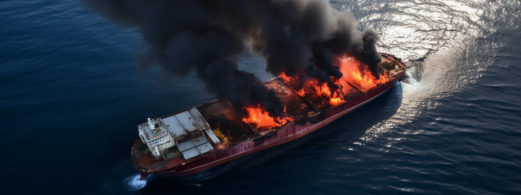
In the Red Sea, commercial ships are being targeted by Yemen’s Houthi Rebels in an attempt to prevent Israeli airstrikes and ground force attacks in Gaza in the war between Israel and Hamas. Houthis have stated an intention to attack all ships going to and from Israel and U.S. Central Command has shot down 14+ “unmanned aerial systems launched from Houthi-controlled areas of Yemen.” On December 19th, the U.S. launched the Red Sea Force called Operation Prosperity Guardian, a multinational operation (U.S. says over 20 nations have signed up) conducting joint patrols to protect vessels traveling through the Red Sea and the Gulf of Aden.

https://www.defense.gov/News/News-Stories/Article/Article/3624836/ryder-gives-more-detail-on-how-operation-prosperity-guardian-will-work/
In response to the attacks, major shipping companies like Maersk, COSCO, and CMA CGM have suspended travel through the Red Sea and have begun to impose surcharges to reroute shipments (Reuters list of company responses). The implications of the rerouted shipments are vast reaching with severe delays expected, higher costs for everyday goods, and increased congestion at other key ports and canals. Additionally, the weeks leading up to Chinese Lunar New Year on February 10th is a peak shipping time for many companies which already means congestion and delays without the added reroutes.
Further complicating matters, with the drone and missile attacks on commercial vessels in the Red Sea, ship crews have resorted to disabling their AIS (Automatic Identification System), an important tool for monitoring a vessel’s position and status. AIS is the primary tool for maritime tracking systems such as marinetraffic.com for real-time tracking of a vessel. As drone attacks loom, knowing a vessel's location becomes a risk, and shutting off the AIS lowers the chances that a vessel will be targeted from a distance. This poses a challenge for OSINT Analysts, without vessel positioning we can’t effectively monitor and track the unfolding conflict.

Present vessel locations in the Red Sea based on AIS
Leveraging satellite imagery can compensate for the limitations left by AIS. However, users with free accounts face constraints tied to the day and time that a satellite passes over the region and any inclement weather that may hinder visibility. While free tools like EO Browser by Sentinel Hub offer great results, the delay of free resources means that in the event of an attack, imagery may only become available hours or days later.

Sentinel Hub EO Browser Satellite Imagery of the Red Sea
Adapting to the New Normal
Echoing a violent history, the future of maritime trade sits at a crossroads of geopolitical tensions and global shipping. Navigating these issues requires a collective commitment to maritime safety and security from governments and the shipping industry. Anti-drone technology may need to become the norm onboard commercial vessels that frequent conflict areas, potentially disrupting or disabling them before an attack. Shipping companies can provide training to crews on evasive maneuvers and safety in conflict zones, diplomatic efforts and de-escalation initiatives should be prepared and pursued. As OSINT Analysts we play an important role in monitoring the seas and reporting verifiable and fact-based information and intelligence. Only through active global participation can we navigate this new normal and ensure the seas remain an artery of peaceful trade, not a battleground for endless conflict.